
MENU


We make the most of every lake, every breeze, and
every chance to get on the water.


Directions to our 'typical' location for Octhobiefest
•I-25 south to exit 83
•Turn left (go under freeway)
•Approx. 50 yds – turn left on state 195
–This is a curvy and rough road, watch your speed
•Reach “triangle gas” in about ~2.2 mi.
–Follow main road as it angles right (south)
•Reach Park Entrance (on left), ~1.6 mi.
•From park entrance circle to left (north)
–This is officially “ridge road”
–(Straight will put you at the marina)
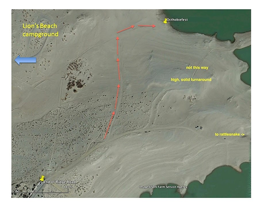
From the end of road, proceed on the dirt road to first major left-hand fork.
DO NOT try to take the short path from the high solid promotory - many have gotten stuck!
Proceed north until you see solid path at the bottom of the 'valley.
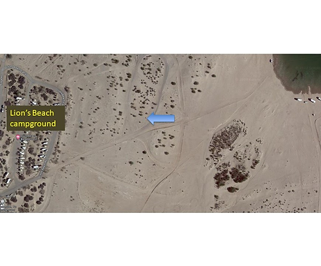
alternate path through Lion's Beach Campground
You can also proceed on the PAVED road from Ridge Road - TO Lion's Beach campground.
then proceed straight toward the beach - this is usually a good road.
Closer to the beach can get sandy so usually stopping and getting out to scope your path is recommended!!!
Note the water level in this picture is higher than one above.

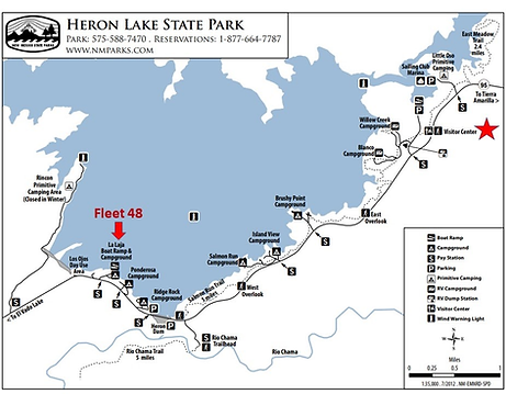
"Hobie beach" is approximately 165 miles from Albuquerque and 104 miles from Santa Fe.
www.emnrd.nm.gov/spd/find-a-park/heron-lake-state-park
2025- July update - see image at bottom for possible 'short-cut' from the boat ramp - scope it first!
conditions change daily!!!

To get to "Hobie Beach" turn at La Laja campground, make a right before the boat ramp, then a left down the dirt "Hobie road" and continue to the beach. It has moderate ruts and is very slippery when wet.
To get a larger image zoom in, or right-click and "open in new tab"

July 2025 - boat ramp option to Hobie Beach
An alternate route to Hobie road above - look near end of boat ramp for a 'horizontal cut' across toward Hobie Beach. This path was passable at Memorial Day 2025 and was an attractive alternative as Hobie Road is getting bigger ruts...
Please scope and make your own decision!! Conditions can change daily!


Water Levels: Storrie Lake - Park Alerts (nm.gov)
Website with map: https://www.emnrd.nm.gov/spd/find-a-park/storrie-lake-state-park/
70 miles from Santa Fe
125 miles from Albuquerque 'Big-I
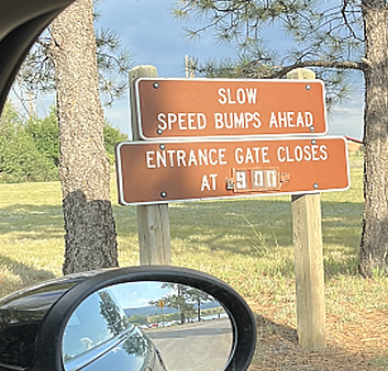
The driveable lake area is small, so you will see us. Please be aware that there's a gate at this reservoir that is locked at 9 p.m.
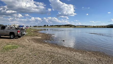

Overview
Historically Storrie has great westerly winds coming down off the mountains headed for the plains.
Some shallow areas exist, typically well marked with hazard buoys.
Camping and boat launching right on the beach!
IMPORTANT NOTE: Entrance to park closes at 9 pm in summer and may vary - always check!
Only 5 minutes from town - restaurants, hardware, etc.

How to get there
I-25 north to exit 347
Turn left, go under freeway
~0.3 miles turn right on Legion Dr.
Slow! Speed bumps
~0.7 mile turn right on 7th st (NM518)
~2.7 mile left turn into park entrance



Directions to Conchas Lake Cove Campground from Abq
Boat Ramp @ Cove Campground = 35.4226486, -104.1932466
• Going east on I-40 from ABQ
• Proceed ~126 mi to exit 300 (NM 129) town of “Newkirk”
(turning ~30 mi. before Tucumcari)
• Proceed north ~17 mi on NM-129
• Turn right at NM-104 (Road ‘tees’) - see photo below
• Proceed ~6mi to Bell Ranch Road (left at the Y) (just after the post office - see photo below
• ~2.3 miles to Dam
• Continue 1.9mi past Dam to Marina Loop Rd.
• Second left onto Marina loop – see photos below
• Right to campground - see photo below
Directions from Santa Fe - two options
-
~162 miles
-
Take US-285 from Eldorado south to I-40
-
Follow directions above (about 162 mi. total)
-
-or-
-
~146 miles
-
Take I-25 north to Las Vegas, NM
-
Exit 345, turn right on NM-104
-
follow NM-104 to the town of Conchas join directions above after post office

Driving north on NM-129, road 'tees' w/ NM-104

Left at the "Y" right after post-office
approx. 4.2 miles to Marina Loop

Second Left!
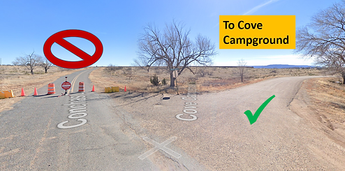
Follow loop around until split to Cove Campground
COCHITI LAKE
Cochiti Lake State Park does not allow shoreline camping like other New Mexico lakes, so we typically use it for day sailing. There are three launching sites: 1) main boat ramp, 2) "Tetilla Beach", and 3) Tetilla boat ramp. Overnight tent and RV camping is available, but it is not near either of the two ramps or Tetilla Beach shorelines, and you cannot leave your boat just "beached" and tied down. You can leave your trailered boat overnight in the ramp parking areas or you can trailer it back to your campsite.
Always watch for the individual event information on our private social media to know where the fleet will specifically gather and launch for any given Cochiti event. If you would like to receive this information, please Contact Us.
